
Topic: Landforms
Landforms
The block diagram below represents two parallel mountain ranges.

Which two geologic processes most likely created this landscape region?
(1) volcanism, followed by metamorphism
(2) faulting, followed by deposition
(3) folding, followed by erosion
(4) glaciation, followed by rifting
Which two cities are located in the Interior Lowlands?
(1) Elmira and Binghamton
(2) Riverhead and New York City
(3) Massena and Old Forge
(4) Buffalo and Watertown
Huygens Probe Lands on Titan
The Huygens probe was carried to Saturn by the Cassini spacecraft and parachuted to the surface of Saturn’s giant moon, Titan. The Huygens probe’s landing site was littered with smooth, rounded, rocklike objects. Photographs taken of Titan’s surface show drainage channels leading to an apparent shoreline. The question is, what are they draining? One of the photographs seems to show ground fog consisting not of water, but perhaps of ethane or methane.

What natural process occurring on Earth produces smooth, rounded rocks similar to those found at the probe’s landing site on Titan? [1]
Allow 1 credit. Acceptable responses include, but are not limited to:
• — weathering and/or erosion
• — rock abrasion
• — transport by running water
• — wave action


The surface elevation of Lake Huron is 176 meters above sea level. Identify one New York State river that receives water that flows from Lake Huron. [1]
River
Allow 1 credit for Niagara River or St. Lawrence River.
Devastating Tsunami
On March 11, 2011, one of the largest earthquakes ever recorded (magnitude 9.0) produced a 7-meter-high tsunami that devastated Japan’s eastern coast. Thousands of people died and billions of dollars in damage occurred. Several hours after the earthquake, the tsunami reached the Hawaiian Islands and parts of North America’s west coast.

Identify by name the two tectonic plates labeled on the map above that are located directly on each side of the earthquake epicenter. [1]
__________________________________ Plate and __________________________________ Plate
Allow 1 credit for Pacific Plate and Okhotsk Plate.
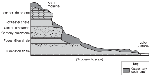
The Niagara Escarpment
A prominent feature found along the shore of Lake Ontario in western New York State is the Niagara Escarpment. This escarpment is the remains of an ancient seabed that was formed when the area was covered by a warm, shallow sea from approximately450 to 430 million years ago. Erosion of the Taconic Mountains to the east provided
the sediments deposited in this basin area. From these sediments, rock layers such as shale, sandstone, and limestone formed. Later, magnesium replaced some of the calcium in the top layer of limestone, turning it into a dolostone layer. When the high ocean levels of the Ordovician Period dropped, the draining of this inland sea caused unequal erosion of the exposed layers. The South Moraine was deposited on the top of the Niagara Escarpment in this region.
Describe the inferred position of North America when this area was covered by the warm, shallow sea. [1]
Allow 1 credit. Acceptable responses include, but are not limited to:
• — North America was located on/near the equator.
• — North America was located at a lower latitude.
• — It was farther south.
• — mostly in the Southern Hemisphere
• — farther east
• — southeast